 |
||||||||||||||||||
|
Maps The Middle East
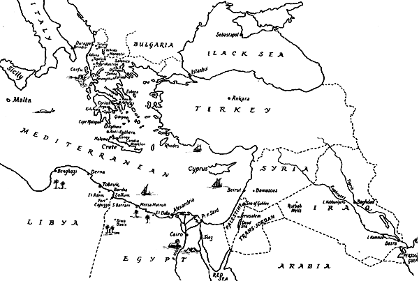
Charming in its little details, this map by the George Allen & Unwin staff artist for the end-papers of Tommy Wisdom’s book in my collection gives a good sense of the extent of the Middle East theatre. From Malta to the head of the Persian Gulf (more or less the East-West extent of the sketch) it is close to 2,000 statute miles. From Alexandria, the Libyan border lies some 300 miles West, while Malta is 950 miles to the West, and Athens about 600 miles to the North. Well off this map, Port Sudan on the Red Sea lies about 900 miles South. Gibraltar, great gateway to the Mediterranean, is over 2,000 miles to the West of Alexandria and again, well off the map—and from there, Liverpool in the United Kingdom is still 1,500 miles away by sea. Notably, drawn around 1942 and the ebullient Lamb not withstanding, the map is quite right about the Greece—Albania border: Paramythia is just visible and plainly on the Greek side. Position of El Daba in the Western Desert added by me.
From Cole’s Imperial Military Geography (Sifton Praed 1937) in my collection, with my highlights for RAF Stations and other places associated with 211 Squadron activities. The map covers the Suez Canal, the Nile Delta and Cairo area. This map covers some 210 miles from East to West. Egypt and The Sudan
From Cole’s Imperial Military Geography (Sifton Praed 1937) in my collection. In this period, railway lines were often clearly marked, whether existing or hoped for. Indeed, at Home and abroad, the RAF of the time took care to place its own Stations in close proximity to those on rail lines. From Ghat on the Western border of Tripoli (Libya) to Medina in Saudia Arabia is about 1,900 statute miles to the East. From Cairo South to Khartoum the distance is over 1,000 miles. Wadi Gazouza lay about 60 miles South-West of Port Sudan on the line to Haiya. There the line branched, continuing West to Atbara and Khartoum or on South to Kassala. Cairo
On this tear-sheet from a Services leaflet of about 1940 vintage in my collection of Dad’s papers, the Empire Services Club on Shari Emad El Din (now Shari Muhammad Farid) is marked by hand, suggesting it was available to NCOs. The face of Central Cairo is much changed since 1940, in streetscape and name. The Egyptian Museum and the Abdin or Abidin palace remain recognisable landmarks today, whereas the Ezbekiah Garden is much reduced, built on in part and divided by a main thoroughfare. Many streets have been renamed and much reshaped. On this little map, perhaps not to scale, the area shown may be about 3 miles across. North to the left.
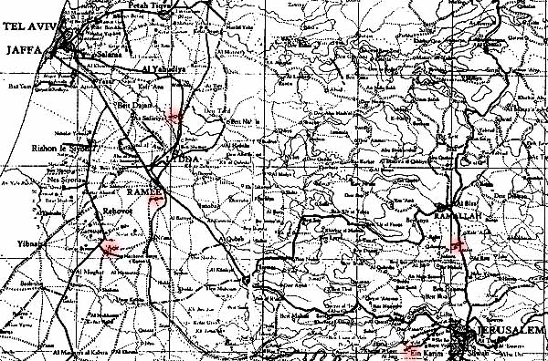
Part of a Palestine map showing the airfields at Lydda, Ramleh and Kolundia marked by propeller symbols, with my added highlights for places associated with 211 Squadron in 1938 and 1941. The grid squares are at 10km intervals, so the area shown is about 37 miles from East to West. Aquir is to the South of Ramleh. Kolundia, Jerusalem airport today, lies 10 miles to the North of Jerusalem on the Ramallah road. Ain Karim is 5 miles outside Jerusalem. Off-map far to the North, Semakh lies on the southern shore of Lake Tiberias (the Sea of Galilee).
This map in my collection shows useful topographic and road detail, including the main oil pipeline to Haifa with its then well-known pumping Stations (H4, for example). Aerodromes are marked by a red aeroplane symbol. This cropped selection shows most of Palestine, Transjordan, and part of Iraq (including Rutba). The grid squares represent an interval of 120 miles. The area shown is something over 400 miles wide from West to East. RAF Habbaniyah (near Baghdad) lies some 180 miles further East of Rutbah, well beyond the margin of this image.
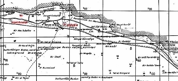
Part of a captured German map of January 1942 issue, showing the Western Desert coast road, the railway, and other features like the dune country to the North-East of the village of El Daba. The areas with birdlike symbols indicate landing grounds, with spot heights in metres. My added highlights show El Daba, Quotaifiyah and the landing grounds used by 211 Squadron. The grid squares are at 10km intervals, making this section of map some 30 miles wide from East to West.
Greece during the period of BAFG operations from 1940 to 1941, from the RAF Narrative—Middle East Campaigns Volume VI: The campaign in Greece 1940—1941 (AHB 1946: MLRS facsimile) My added highlights draw attention to those airfields associated with 211 Squadron operations and to the northern border with Albania (correctly mapped in its post-1913 Treaty of Bucharest position). Paramythia lies some 20 miles to the South in Greece, the redoubtable Lamb notwithstanding. The apparent proximity of Menidi (“airfield”) and Tatoi (“town”) on this map may have resulted in the occasionally reported notion of two airfields there. Curiously, the map scale as labelled with single mile intervals is patently incorrect: apparently 10 mile intervals were intended.
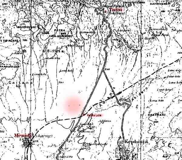
Part of a World War I British map of southern Greece. My added highlights show the Summer palace of the Greek Royal family at Tatoi, nestled in the slopes of Mt Parnes (modern Parnitha) on the upper margin of the map; the village of Menidi (with its own railway station); and Tatoi railway station. The civil airfield was to be developed immediately to the North-West of Tatoi railway station and the road (as highlighted). With a grid interval of 5 minutes of longitude or latitude respectively, this part of the map is about 7 miles by 7 miles in extent. By 1938, Tatoi was already the principal Athens airport and military flying establishment. Even so, in 1940 the proximity of the Royal palace and railway station of the same name gave rise to some local confusion. For convenience, in reporting attacks for example, the RAF thereafter referred to it as Menidi (Tatoi). Athens is 10 miles to the south but today the suburbs stretch all the way to Kiphissia and beyond. The country here suffered grievously in the great forest fires of 2007.
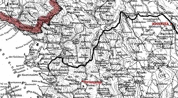
Part of a German war-time map of Northern Greece with my added highlights showing the Albania-Greece border, Paramythia and Yannina. Again, despite Lamb’s view, Paramythia lies about 20 miles South of the border, in precise agreement with earlier (post-1913) maps and with a number of British theatre maps of the period. Lacking a grid, the map area here is about 40 miles from East to West. Northern Greece Easter Sunday 1941
James’ account the Easter Sunday raid and the six lost crews of 211 Squadron, Blenheim Over the Balkans in my collection, includes this self-drawn map of the aftermath of the air battle with the Me109Es of 6/JG27. The raid that afternoon was an unescorted daylight attack on German forces advancing South through Florina, on the Greek side of the Monastir Gap some 120 miles NW of Paramythia. The crash sites of the six Mark I Blenheims lie along a line running ESE for about 12 miles right on the northern border of Greece, from the village of Vigla to end in the Southern reach of Lake Mikro Prespa. The Sudan The grid here is 1 degree of Longitude by 1 degree of Latitude which, this near the equator, makes each square about 65 miles wide by 70 miles deep. This small portion of the sheet shows Port Sudan and the railway South, along with the halts so well known to the 211s: Gebeit, Sinkat, and Summit. Even little Erkowit, 20 miles in the Hills beyond Wadi Gazouza, is shown. The course of the Wadi itself is indicated in blue. My added highlight shows the Wadi Gazouza airfield, marked in red, about eight miles East of Summit, abreast the unsealed Erkowit road (as shown in Alan Conrad’s fine print of the aerial photograph). There was then a track of sorts from Sinkat, too, though longer and through more difficult country. Today the roads South from Port Sudan and out to Erkowit are sealed. The Wadi Gazouza airfield site is still visible in modern digital mapping (as are the Summit and Carthago/Erkowit airfield sites, 2 miles and 12 miles east east of the village). The Far East 1942
From the copy in the National Library of Australia (NLA Map 8080 S250 Sheet 1). The area around Koetaradja (modern Banda Aceh), showing all-weather roads in solid red, the narrow-gauge railway in black, the open black circle representing the town proper with telegraph office (KP) and the Provincial Governor’s Residence (GR). The metric grid interval represents 10km, that is about 6.2 statute miles. The red concentric circles show Koetaradja aerodrome, 6 miles South East of the town, and little Loh’nor (Lho’nga, Lhok Nga) airfield, 6 miles to the South West. Although KNILM, the Dutch East Indies airline, had planned a route from Medan to Koetaradja from the late 1930s and still showed it as a terminus in a 1941 map, few maps of the time showed either airfield. This 1945 War Office edition, based on earlier Dutch work, shows both. Bateson and co landed at Lho’nga, as did Dundas and co, Clutterbuck, Newstead and Joerin, Burrage and his crew and Cuttiford and his crew. West, Ritchie and Keeping landed at Koetaradja. After the long flight from Burma, there were some difficulties finding the airfields and reportedly, some local sensitivity about using them.
From the copy in the National Library of Australia (NLA MAP G5741.P5). My added highlights show left, Palembang far up the Moesi River; top, the small port of Muntok on Banka Is at the mouth of Banka Strait where evacuee vessels from Singapore called en route to Java; and centre, mid-strait, Nangka Light in the Nangka Islands group, where George Kendrick and his pilot Don Chalmers were rescued in February 1942.
From the National Library of Australia collection (NLA Map 8080 S250 Sheet 54, Sheet 63). Both sheets derive from earlier Dutch survey work. Legend and grid interval as for the Koetaradja sheet above. By digitally joining parts of adjacent sheets at the same scale, it is possible to show both Palembang I (P1), top right, the pre-war KLM and KNILM civil aerodrome at Talangbetoetoe (about 7 miles North West of Palembang town) and bottom left, Palembang II (P2) airfield in the jungle near the railway and oil pipeline at Karengendah (some 32 miles South West or about 42 miles by road from Palembang town).
Telukbetung at the head of Lampung Bay on the South tip of Sumatra. On the Eastern side of the Bay (right), the port area of Oosthaven ( ie East Haven) as it was at the time that the Squadron’s Sea Party saw it in February 1942. From the British Admiralty chart Plans on the South Coast of Sumatra Sheet 3611, in the National Library of Australia (NLA MAP G5741.P5).
Sheet I of West Java. From the map set in my collection. Roads in red, main rail lines in solid black. Cropped to show Batavia and its port of Tanjong Priok, top left, and to the East, the rail junction at Tjikampek (Cikampek) and Kalidjati, home of the NEI Flying School, both highlighted in pink. Kalidjati was over 120kms East of Batavia by road via Tjikampek. It was very interesting to see, on the main road and rail link South of Tjikampek, the town of Poerwakarta (Purwakarta today). From there, the main routes to the South coast continue on through Bandoeng and Tasikmalaia to reach Tjilatjap more or less directly—but see also Sheet II, below.
That is, Sheet II, Middle Java, from the map set in my collection, showing the South Coast port of Tjilatjap highlighted in pink, lower right. The rail junction 50-odd kilometres (over 30 miles) to the North is also highlighted: another Poerwokarta (but today, Purwokerto). While the two rail towns of this name must both have been familiar to the men of 211 Squadron, the accounts or photographs of Mick Dudman, Jim Fryatt and Tom Henderson for example (and confirmed by Kirby’s official account) indicate it was this Southern town, with its nearby volcano and sugar factory, as the place where they camped briefly while awaiting transport on to Tjilatjap. As the crow flies, Tjilatjap is some 300km South East of Batavia; or about 400km by road via Tjikampek, Poerwakarta (Purwakarta), Bandoeng and Taskimalaia. Java is a big place: these two crops are each about 140km from East to West. India and Burma At 1:4,000,000 the scale of of this map, for what was then Bengal and Burma, suggests just how big India is as a whole. At such a scale, the map can only show a selection of places and thus only a selection of those known to 211 Squadron.
Sources www.211squadron.org © D Clark & others 1998—2025 |
||||||||||||||||||


 The Anglo-Egyptian Sudan 1:3,000,000 (War Office 1914, 3rd Edn 1934) [Author collection]


 Main Physical Features of Eastern India, Assam and Burma 1:4,000,000 (HMSO 1951)
  Main Physical Features of Eastern India, Assam and Burma 1:4,000,000 (HMSO 1951)